Under the Ben Franklin Bridge, on Pier 11 (which may or may not some day be a public park), the National Oceanic and Atmospheric Administration has a tidal gauge,
measuring the daily rise and
fall of the Delaware River. That station is exactly 100.0 miles from the river's exit at the Atlantic Ocean. That exit, the mouth of the Delaware Bay, is an invisible
line traced from the tip of
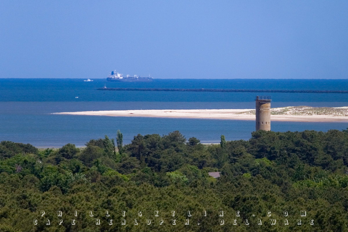
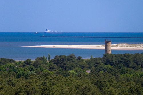
Cape May, New Jersey to Cape Henlopen, Delaware, pictured here.
The white bar in the middle is the northern tip of Cape Henlopen's peninsula distinguishing the Delaware River and Bay from the Atlantic Ocean, a dune of sand that's
the tallest between Cape
Hatteras and Cape Cod. Out past the breakwater is a transatlantic bound ship that departed one of the Delaware Valley ports. The cylindrical concrete structure is a
relic of World War II, when
the US Army established Fort Miles on the cape. From 1939 to 1941, the army built eleven of these observation towers on the Delaware side and two on the Jersey side to
protect the ports of
Philadelphia, Camden and Wilmington against enemy attack. One of them, called simply the World War II Observation Deck, is 94' tall and is open to the public.
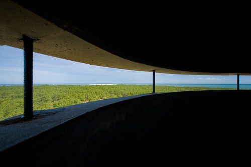
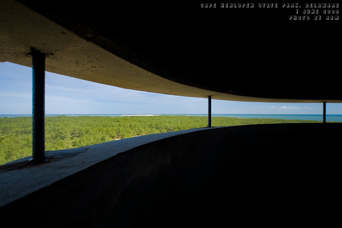
From the top, you're afforded a 360° view, south to Rehoboth Beach, east across the horizon of the Atlantic, northwest into the Delaware Bay's interior, northeast
to Cape May 17 miles away,
west across the former fort which is now Cape Henlopen State Park, and just across the treetops, the little town of Lewes.
Lewes, Delaware -- pronounced "lewis", not "lose" -- is probably most familiar to us as one half of the Cape May-Lewes Ferry (Summer
of the Delaware, vol. 22), but its history is the oldest of all non-native establishments in the Delaware Valley.
In 1524, Giovanni da Verrazzano became the first European to explore the east coast of the future United States, including a pass around the Delaware Bay. (In the
thirty-some years before that,
Christopher Columbus had explored the Caribbean, but only the islands and the coasts of Central and South America. Leif Ericson and the Vikings had explored the
northeastern parts of modern
Canada and Greenland around 1000 AD.) Verrazzano, who is commemorated by a plaque on the Rehoboth Beach boardwalk, described the natives he encountered:
These people are the most beautiful and have the most civil customs that we have fund on this voyage. They are taller than we are; they are a bronze color
. . . the hair is long and
black and they take great pains to decorate it; the eyes are black and alert, and their manner is of the ancients . . . they have all the proportions belonging to any
well-built men. Their women
are just as shapely and beautiful.
This passage is from the introduction of Frank Dale's excellent Delaware Diary, Episodes in the Life of a River (Rutgers Press, 1996.) The first chapter of the same book is titled
"Nasty Little Village" -- an
early English description of the town we now know as Lewes.
In 1609, as the English had already settled Jamestown, the French had Québec and the Spanish were settling the Caribbean and South America, the Dutch laid claim
to New Netherland -- an
area encompassing the modern Connecticut, Hudson and Delaware valleys -- to establish and exploit fur trade with the natives. Henry Hudson, an Englishman, was hired by
the Dutch East India
Company when he claimed he could find the northwest passage to Asia. He did not, but he did determine that the Hudson (New Netherland's "North River") was more
navigable and therefore useful to
the Dutch than the Delaware ("South River"), which was shallower and required smaller vessels. As such, the Dutch made Manhattan their center of operations.
Their South River did not go untouched, though. The Dutch explored as far north as Burlington Island and the Schuylkill (which, as we know, is Dutch for "Hidden
River"). Meanwhile, in 1610,
English naval officer Samuel Argall, who was later responsible for the kidnap of Pocahontas, developed the shortest route of travel between the kingdom of England and
the Virginia Colony, at the
time governed by Thomas West, Lord De La Warr. On one such travel, Argall passed into the sparse bay and named it for the governor; Delaware is how the bay, and
the river that flowed into
it, and the Indians that inhabited it, would all be designated by the English.
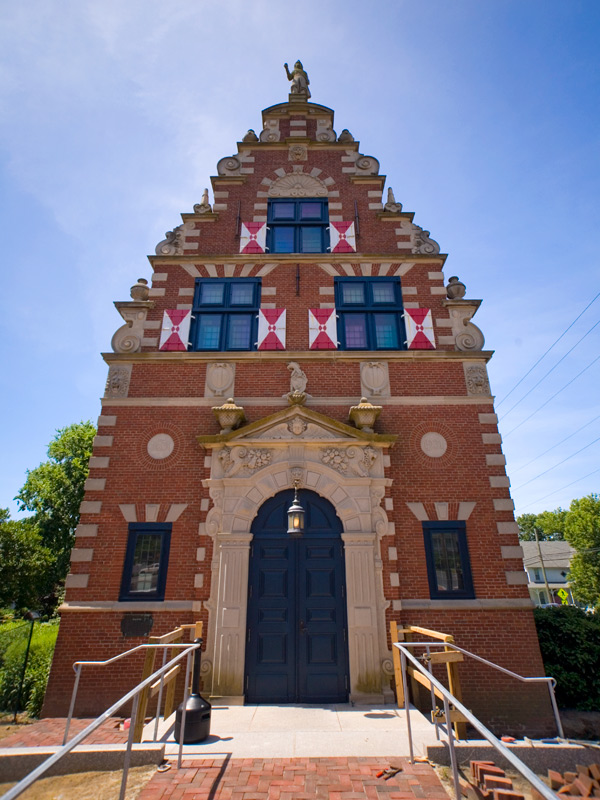
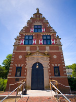 It was in 1631 that the first permanent settlement in the Delaware valley took shape. At the mouth of an oyster creek they named Hoornkill after a village in the
Netherlands, the Dutch set up
the town of Zwaanendael -- "valley of swans" -- for the purpose of trading, farming and whaling. There is now a Zwaanendael Museum in Lewes (pictured at right), built in 1931 for the settlement's 300th anniversary and modeled after the town hall of Hoorn in
the Netherlands.
It was in 1631 that the first permanent settlement in the Delaware valley took shape. At the mouth of an oyster creek they named Hoornkill after a village in the
Netherlands, the Dutch set up
the town of Zwaanendael -- "valley of swans" -- for the purpose of trading, farming and whaling. There is now a Zwaanendael Museum in Lewes (pictured at right), built in 1931 for the settlement's 300th anniversary and modeled after the town hall of Hoorn in
the Netherlands.
According to Delaware Diary, the Dutch colony's governor had a Lenni-Lenape beheaded for stealing a Dutch coat of arms, and the tribe retaliated by killing all
of Zwaanendael's 30
inhabitants and destroying its buildings. While the little town at the mouth of the bay remained a trading post, it was not resettled until 1663, the name changed to
that of the creek,
Hoornkill. It was the next year that it became the nasty little village again.
In 1664, Peter Stuyvesant surrendered the Dutch colony he governed to the English, and New Amsterdam became New York. Under the Duke of York (brother of English King
Charles II), the English's
claims extended down through New Jersey; at the same time, Lord Baltimore's Maryland claims for the English extended up to the west shores of the Delaware. York and
Baltimore disputed the land
(including Hoornkill) until they united under the crown when England declared war on the Netherlands in 1672. Under the English, Hoornkill was anglicized to the
charming Whorekill.
In the following ten years, Whorekill suffered another takeover by the Dutch and yet another by the English. (Mind you, the Swedes had also set up shop in a few
locations upriver in the
preceding decades with the blessing of the Dutch.) In these handovers, the citizens of the town were each time forced to swear allegiance to the respective Dutch and
English crowns, and after
the last one, Maryland's governor (Baltimore's son Calvert) decided to 'teach them a lesson' and burned their village while they watched. And of those who decided to
relocate 60 miles upriver to
New Castle, some were murdered along the way by hostile Indians.
After stabilizing as a port under English rule, Whorekill petitioned for and won a name change from the governor of the Middle Colonies (which was basically the
British's rule over the former
New Netherland) -- "New Deal". The new name came with a new courthouse in 1682 -- around the time a whole new way was coming.
A Quaker called William Penn came with a deed from York's brother the king for what would become Pennsylvania and Delaware. In his short tenure in the colonies, he
changed the name of "New Deal
alias Whorekills" to Lewestown, which was eventually shortened to Lewes. Penn also set aside land on Cape Henlopen "for the usage of the citizens of Lewes and Sussex
County," effectively
creating an early beachfront park.
In its 327 short years since then, little Lewes at the mouth of the Delaware River and Bay has been the home of skilled sailors for hire (before a channel was dredged,
beginning with steam power
in 1829) and relatedly the site of pirate raids (including a legend of Captain Kidd's burial of a chest of gold on Cape Henlopen), the site of a grassroots American
standoff against a British
Navy bombardment in the War of 1812, the Lewes and Rehoboth Canal (whose drawbridge you pass over on Rehoboth Avenue) one hundred years later, World War II's Fort
Miles, and beginning in 1964,
the Cape May-Lewes Ferry.
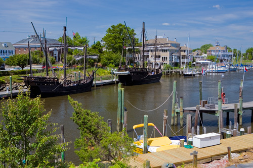
For a town of 3,000 resting in the shadow of the better known Cape May and Rehoboth Beach, Lewes packs a historic punch, largely of Dutch flavor but embellished by
three centuries of English and
American rule with a sprinkle of Swedish. Funny, then, that in my visit over the weekend, the two ships of interest at Lewes' port were replicas of vessels that never
saw the Delaware sailed by
a man who never knew America: Christopher Columbus' Niña and Pinta.
Lewes, Delaware is an easy two hour drive away, and is a must-stop for anyone interested in the history or geography of the Delaware River. And hey, it's right on the
way to Rehoboth and its
sun, sand and sexy queens.
NOTES & SOURCES:
• The New Netherland Project, Virtual Tour.
• Zwaanendael Museum, State of Delaware.
• Lewes Facts, beach-net.com, beach travel guide to the Delmarva
Peninsula.
• The District: A History of the Philadelphia District, U.S. Army Corps of
Engineers 1866-1971
(PDF), "Early Dredging," 1974.
• Delaware, A Guide to the First
State, compiled and written
by the federal writers project of the Works Progress Administration for the State of Delaware, Viking Press, 1938.
• Delaware Diary, Episodes in the Life of a River, Frank
Dale, Rutgers Press,
1996.
• Opportunity Valley, Edwin York, Xlibris,
2007.
–B Love
|