In Philadelphia's Delaware River, the bridges across it are pretty straightforward, well used and well known: Tacony-Palmyra, Betsy Ross, Ben Franklin, Walt
Whitman. And oh, don't forget about the Delair railroad bridge. That's it, end of story.
Or is it?
Well . . . yes and no.
Philadelphia's Delaware River covers twenty-three shoreline miles, from the Poquessing Creek to the international airport. And indeed, those five bridges are the
ones leading into and out of Philadelphia. But in those same twenty-three miles, there is another bridge across the Delaware -- a hidden bridge, a Petty
bridge.
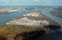
The island called Petty's is the 300 acre, triangular piece of private controversy nestled midstream in the Delaware, about halfway between the Ben Franklin and
Betsy Ross Bridges. It's relatively little known locally because it's been entirely private since the 1960s. The only people going there are employees and truckers.
Petty's Island -- technically Petty Island, according to the US Board on Geographic Names, but for our
purposes, the locally accepted Petty's Island -- has a long history, far longer than a man named Petty ever inhabited it. It has had several names: the
Lenapes' Shackamaxon Island (it is positioned in the river directly east of Fishtown, where William Penn's famous treaty with the Indians at Shackamaxon allegedly
happened), Aequikenaska from 17th century Swedes here before Penn, and Treaty Island from nostalgic industrialists in the mid-19th century, but the name we know it
by today stems from Philadelphia's early heyday: the American Revolution, when it was also placed into New Jersey's jurisdiction. The Quaker John Petty inherited
the island in 1732 from Thomas Fairman, who controlled the island at the time. It was under Petty's ownership when Philadelphia was the center of the American
Revolution, and its name has stuck ever since, retaining the handle in spite of the efforts to change it to Treaty Island in the 1850s. USHistory.org has more on
the early history of Petty's Island HERE, and Will Van Sant compiled a more recent
account for the Inquirer in 2001, archived at camdennewjersey.org HERE.
Petty's Island's history is equally as odd as it is long. It had a certain renown as a Quaker place of ill repute (it was far enough away from old Philadelphia's
elders and it was relatively lawless), it was the site of slave auctions, it was the site of duels, it was supposedly a landing place for Blackbeard the pirate,
and it was the site of unadulterated debauchery -- Party's Island, if you will. And, oddly, it took industry to refine Petty's Island. The Crew Levick
Company, an early gasoline company, had been on the island since at least 1906 (New Jersey State Treasurer's Report, 1907). Cities Service Company, a
predecessor to
Citgo, purchased Crew Levick in 1916 (Citgo corporate
history) and has been there ever since.
 It's Citgo who owns Petty's Island now, using only a small portion of it for fuel storage, and leasing out space to Crowley Maritime Corporation, whose ships one
can see docked from Penn Treaty Park. The island's odd history continued into 2005, when it was a hot button issue in New Jersey's gubernatorial election. Citgo,
the large oil company, had volunteered the island for a natural preserve. Jon Corzine, the Democrat (usually the environmentalist's party of choice), claimed this
was
suspect and that Citgo was trying to get out of costly remediation. Doug Forrester, the Republican, called this grandstanding and that Corzine was effectively going
to bat for Pennsauken's development of the island, led by powerful Pennsauken Democrat George Norcross. Pennsauken's development plan of choice at the time belonged
to Cherokee Investment Partners, who wanted to created 700 homes, a 250 room hotel and a golf course. (See the New York Times' 2005 series on this HERE and HERE.)
It's Citgo who owns Petty's Island now, using only a small portion of it for fuel storage, and leasing out space to Crowley Maritime Corporation, whose ships one
can see docked from Penn Treaty Park. The island's odd history continued into 2005, when it was a hot button issue in New Jersey's gubernatorial election. Citgo,
the large oil company, had volunteered the island for a natural preserve. Jon Corzine, the Democrat (usually the environmentalist's party of choice), claimed this
was
suspect and that Citgo was trying to get out of costly remediation. Doug Forrester, the Republican, called this grandstanding and that Corzine was effectively going
to bat for Pennsauken's development of the island, led by powerful Pennsauken Democrat George Norcross. Pennsauken's development plan of choice at the time belonged
to Cherokee Investment Partners, who wanted to created 700 homes, a 250 room hotel and a golf course. (See the New York Times' 2005 series on this HERE and HERE.)
Well, none of those things has happened -- Cherokee's out, it's still no nature preserve, and Citgo still owns and operates the island -- and here we are on the
outside looking in. It might have been the feeling Citgo (Cities Service) had when it acquired Crew Levick, thinking there must be an easier way to and from
Camden/Pennsauken to the burgeoning oil industry on that island. So when it moved onto the island, it hired a company who knew a little about operating railroads
and building bridges: the Pennsylvania Railroad.
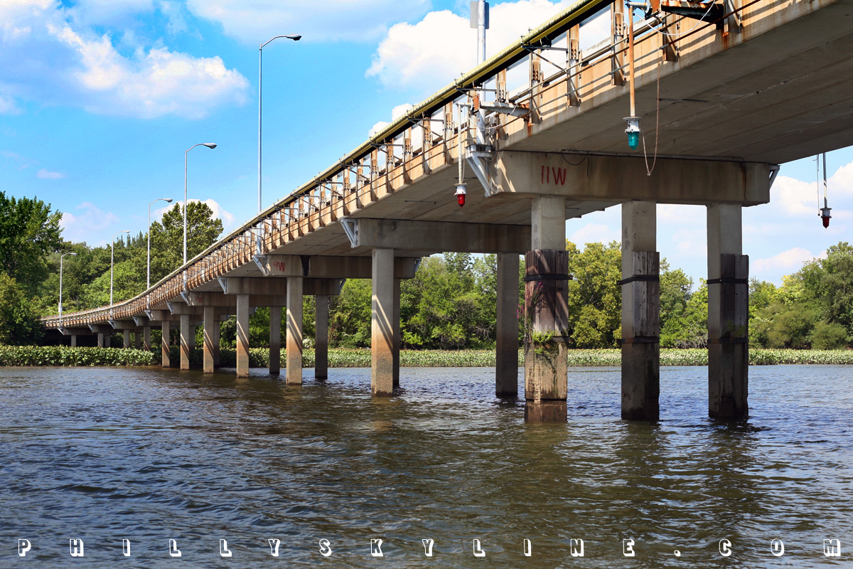
On April 23, 1917, Pennsauken Township authorized the construction by PRR of the first ever bridge to Petty's Island. (Fichter, Jack H, Our Pennsauken,
p 175, 1975.) Built across the back channel of the Delaware, it was a single-track railroad bridge and did not accommodate automobile traffic. Its location at
36th Street -- the border between Camden and Pennsauken -- was accommodating enough, though, having easy access to the industrial city to the south and the growing
township to the east.
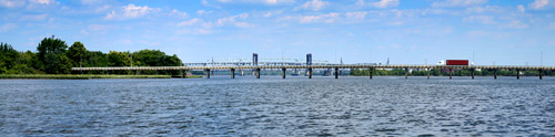
With the main shipping channel of the river on the west side of the island, a bridge here did not need a high level. Its clearance was, and remains, 15' -- enough
for small boats to pass under, small boats like those docked at the Farragut Yacht Club in Camden.
The aerial photo, by Skyphotos and hosted at phillyh2o HERE,
shows a good overview of Petty's Island in 1967, with the main artery in the center of the island being a freight rail line. You can see the oil tankers on that
artery detailed in this 1940 aerial by Dallin Aerial Survey Company, at the excellent Hagley Library (Wilmington, DE) web site HERE.
The 36th Street Bridge, also known as the 'Camden and Petty's Island Bridge' -- continued as a single track railroad bridge until 1989, when Pennsauken authorized
its redecking and paving.

Hello lampposts. Whatcha knowin'? I've come to watch your oil goin'.
And so it is today, the 36th Street Bridge. Camden and Petty's Island Bridge, if you prefer. Only don't expect to just traipse over it and go for a nature walk on
the muddy banks of Petty's Island. 1. It's not a nature preserve and 2. it's still Citgo's island. You need permission from Citgo to be there, and there's a
guardhouse on the Camden/Pennsauken side of the bridge to see to it that you have it.
* * *
For a new mini-essay of photos of the Camden and Petty's Island Bridge (10 total), please click
HERE.
SPECIAL THANKS to Martha Cannon from the Pennsauken Free Public Library and John Adams from the Pennsauken Office of Planning and Zoning for their
assistance in this story.
For additional resources on Petty's Island, check out the following web sites:
• USHistory.org -- historic background on Petty's Island
• "How to Make History, the Easy Way" -- an analytic essay by Ron Gutkowski on
how to handle Petty's Island
• "Freedom Island" -- a proposal of active use for the island
• About Pennsauken -- a history of the township
• Pennsauken Green -- a study of Petty's Island prepared by the Delaware
Riverkeeper
• Sierra Activist -- a gallery of Petty's Island, including photos, active uses,
inactive uses and plans
–B Love
|